 Guest article — excerpted from U.S. Geological Survey Fact Sheet 2018–3032, August 2018 | Download the fact sheet here »
—by Jeffrey R. Kennedy, USGS
Introduction
Newton’s Law of Universal Gravitation says that the acceleration due to gravity at any point depends on the surrounding mass. When the mass of an aquifer changes, either by recharge or by discharge to surface water or wells, the gravitational acceleration at the land surface also changes. Although this change is small, it is detectable with highly precise instruments. In addition to groundwater, gravity measurements are sensitive to Earth tides, barometric pressure changes, mass changes from volcanism, and other effects. Most of these can be accounted for, or are negligible, in groundwater studies.
Since the 1980s, the USGS has developed field methods, software, and analytical procedures for using gravity data to aid in hydrologic investigations. Scientists with the USGS Southwest Gravity Program can measure terrestrial gravity changes with part-per-billion precision to map changes in groundwater storage and to improve models that simulate groundwater flow.
Depth to Groundwater Versus Gravity Change
Changes in both gravity and the depth to groundwater indicate changes in the amount of water stored in an aquifer. For depth-to-groundwater changes, determining the amount of storage change depends on the aquifer-storage coefficient, which is often poorly known and must be estimated based on assumptions about the aquifer. In confined aquifers (those between two impermeable layers), the storage coefficient may be very small, causing large depth-to-groundwater changes even if storage change is small. Whereas depth-to-groundwater measurements indirectly indicate aquifer-storage change, gravity change is a direct measurement of the change in total water stored in an aquifer. In most cases, the measured gravity change, in units of acceleration (for example, m/s2), can be converted directly to a change in the thickness of free-standing water, regardless of the depth to groundwater or the aquifer-storage coefficient.
Groundwater levels are measured at a single point, which may or may not be representative of the aquifer. In contrast, the region of sensitivity of a gravity measurement is well defined by Newton’s Law and encompasses a large volume of the subsurface. A practical guideline is that sensitivity extends to a radius equal to about 10 times the depth to groundwater.
What Are the Hydrologic Applications?
Gravity-change data are useful for estimating aquifer-storage change, for estimating recharge in groundwater systems, and for estimating the aquifer-storage coefficient.
Aquifer-storage change can be estimated both qualitatively and quantitatively. For example, the gravity-change map on page 2 of the fact sheet shows that storage changes are different to the east and west of the groundwater-recharge facility. This qualitative interpretation is possible because the gravity measurement’s region of sensitivity is well known and unaffected by subsurface properties. With other geophysical methods, such as those that depend on the electromagnetic or seismic properties of the Earth, the region of sensitivity changes based on the properties of the subsurface. Quantitative measurements of aquifer-storage change are possible by converting gravity change to an equivalent thickness of water.
Recharge in groundwater systems is often unknown and must be estimated as a residual component of the groundwater budget after accounting for other inflows and outflows in a system. However, with enough gravity measurements to enable interpolation, recharge can be estimated directly from changes in gravity.
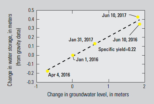
The aquifer-storage coefficient (specific yield in an unconfined aquifer) is the relation between change in the volume of water per unit area (storage, expressed in units of length) and depth-to-groundwater change. It is nearly equivalent to porosity in an unconfined aquifer. Because storage change can be estimated from gravity data, the storage coefficient can be estimated if gravity and depth-to-groundwater data are collected at the same location.
The unique relation between aquifer-storage change and gravity change (regardless of depth to groundwater or storage coefficient) and the well-known, unchanging region of measurement sensitivity make gravity methods a powerful tool for hydrogeologic investigations. From a practical standpoint, gravity measurements are completely noninvasive and have none of the permitting requirements or potential for contamination that exist when drilling groundwater wells.