—by Corey Caulkins
As an ecology student, I feel extremely lucky to have been selected as the 2017 Herman Bouwer Intern Scholarship recipient. It was a great opportunity for me to explore some of the practical applications of environmental science and hydrology, both in the private and public sectors.
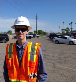
The first half of my internship was spent with Arcadis, an international consulting firm specializing in water, environment, infrastructure, and buildings. I was interested in the consulting world because I perceived it as a more applied use of science than the academic research I’d done in the past, and I wanted to get a more concrete idea of what consulting really entails. Additionally, I really like the idea of an interdisciplinary workforce comprising hydrologists, geologists, environmental scientists, and engineers.
During the first week, I had the opportunity to work on a variety of projects within the environment and water business lines. I learned how to read and decipher a soil contaminant laboratory report, as well as how to manage the data. Additionally, I contributed to a project by researching the history of one of the client’s sites, as well as running a basic leaching calculation for fertilizer contaminants. Finally, I had the opportunity to contribute to a GIS project, involving digitization of water infrastructure features using aerial imagery. Throughout these tasks, I was impressed by the diversity of the projects being undertaken by Arcadis, as well as the fluidity in which employees from different areas of the company coordinate with one another.
To me, the most interesting part of my time with Arcadis involved environmental impact analysis operations. I had the opportunity to review a draft EIS for a mining project for which Arcadis is a subcontractor, and I was surprised by the depth and attention to detail put into the review. It also fascinated me to observe the interaction between regulators, companies, and contractors. I have a strong interest in environmental policy, and feel that I now have a better understanding of environmental regulation. In addition, I was given the chance to learn about ecological risk assessment through a case study on another Arcadis mining project. It was great to see examples of what goes on behind the curtains of environmental impact analysis, which had always been an abstract concept to me in the past.
I had the opportunity to get out into the field during my second week with Arcadis. I tagged along on a quarterly inspection to an industrial site in Tempe, during which the water levels of multiple wells were measured. Through my observation and participation in this process, I learned how a sounder works, as well as how to take proper field notes. Additionally, I obtained a better understanding of how groundwater monitoring works, and what kinds of clients Arcadis performs this service for.
I spent the second half of my internship at ADWR The most memorable part of my time at ADWR office shadowing was an EIS meeting that I had the pleasure of attending at the Tonto National Forest Headquarters. Like the EIS material I worked with at Arcadis, this was for a large mining project. Seeing the inner workings of the meeting helped me understand the work that goes into complying with NEPA and how that work is organized and delegated. I was impressed by the sheer number of stakeholders present at the meeting, who spanned a large variety of federal and state government agencies. Ultimately, I really appreciated the opportunity to peak behind the curtain of such an important part of day-to-day environmental policy in the U.S.
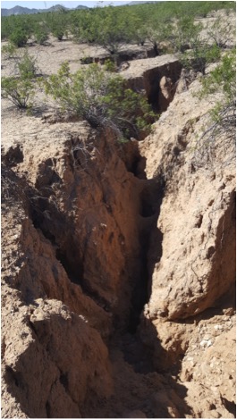
In addition to my office shadowing, I had a full week of field trips. During the first day, I had the opportunity to check out a number of land subsidence sites around Phoenix. These sites were the product of intensive groundwater pumping in the past, which caused the ground above it to sink. Ground directly above of the bedrock split with the sinking land around it, causing deep, thin fractures in the rock below the surface. Over time, disturbances mostly attributed to flooding cause these cracks to open up into massive fissures. I wasn’t previously familiar with the concept of land subsidence, and I was astonished by the sheer size of the sites. These site visits helped me appreciate the complexity of the hydrogeological challenges created by over-pumping groundwater.
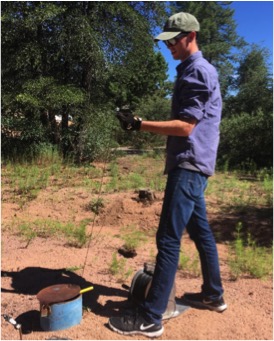
I spent my second field day accompanying the basic data team to Payson, to measure water depths for some of the monitoring wells located there. This was one of my favorite parts of my time with ADWR, as I obtained hands-on experience with groundwater monitoring methods. I learned how and when to use a steel tape, and was able to repeat my measurements with decent accuracy after a few initial attempts. I also had a chance to use ADWR’s in-house sounders, which differed slightly from the kind I worked with at Arcadis. These tools were marked with different colored tape at major intervals and, unlike typical sounders, used a voltage gauge rather than an audible alarm. It took me some time to get used to these instruments (the hardest part was manipulating both the cord and a measuring tape simultaneously), but I collected reasonably precise measurements by the end of the day.
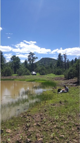
Day 3 of my field week with ADWR was spent up in Tonto National Forest performing a stock pond inspection. Transportation was by far the biggest challenge of this task; not only was the site about two hours away, the dirt roads that provided access to it were nearly impassable. After at least an hour of strategizing and making slow but steady headway, we finally made it to the site. At first, the stock pond looked like a natural pool of rainwater to me. It was only after the field team pointed out the subtle inlet near the front and dirt dam built at the back of the pond that I recognized the artificial design elements. I learned how to use surveying equipment to record the dimensions of the dam, as well as the “fishing pole” method of water sampling, which allows the team to collect a sample from below the surface without having to enter the pond.
I think the most valuable insight I gained from this intern scholarship program was the inside knowledge of how consulting firms and government agencies function. As a researcher, I had only a vague sense of how science was being utilized and practiced outside of the laboratory. Being able to observe and experience applied hydrology and environmental science helped contextualize some of the skills I’ve learned in my courses, and it was exciting to work on solving immediate, real-world problems. Going forward, I will be continuing to intern with Arcadis, and I hope to pursue further education and a career in environmental policy.
I’d like to thank the Phoenix chapter of AHS for awarding me the Herman Bouwer Intern Scholarship and, additionally, Arcadis, and ADWR for hosting me over my 4 weeks as an intern.