—Don Bills, Flagstaff Chapter President
On August 6, the Flagstaff Chapter hosted a field trip to the Middle Creek Watershed about 10 miles south of Williams to learn more about the Four Forest Initiative (4FRI) experiment using paired watersheds, some of the still more active springs in the area, and the remains of some of northern Arizona’s colorful past. The trip was led by Abe Springer, NAU. Forest Service representatives expected to attend and co-lead with Abe were all busy on fires.
The group of about 13–14 people attending the field trip met in Williams at the Café 326 coffee shop for a caffeine and sugar shot to fuel the morning and organize the carpool. As a bonus, there happened to be an antique car show organizing on Main Street as we were arriving and preparing to leave town.
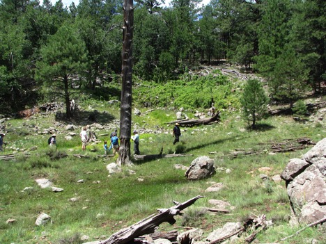
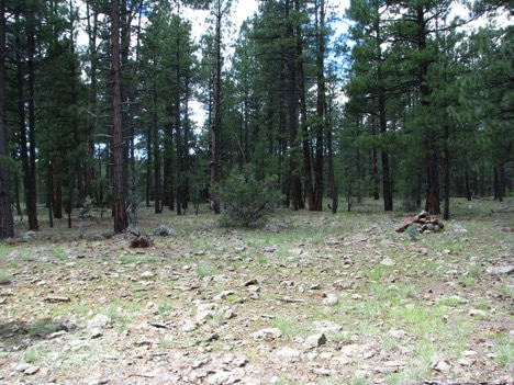
With four vehicles, we drove south out of town on the Perkinsville Road across the east shoulder of Bill Williams Mountain, crossing the Mesa Butte Fault before turning on to FS-100. The surface rock for the entire trip consisted of volcanic rocks and basalt flows that are all part of the San Francisco Volcanic field. Our first stop was a SRP flowtography site just upstream of Mc Dougal Spring (now dry) at the upper end of Big Spring Canyon in MS-4, one of three watersheds planned for treatment (low, medium, and high) as well as one control site (MS-1). The flowtography site consists of a camera mounted on a tree overlooking the stream channel where a staff plate and pressure transducer are located. The purpose of the flowtography sites is to determine surface-water yield from the treated watersheds as one measure of the effectiveness of watershed treatment. Somewhere in SRP’s database, I am sure, there is now a photo of a bunch of happy hydrologists waving at a camera.
Stop 2 off of FS-139 provided an opportunity to view one of the precipitation gages used for monitoring and learn more about the overall objectives of the 4FRI experiment.

Stop 3 was a short walk to Big Spring, a hill slope spring that issues from a heavily fractured and decomposing basalt flow in a heavily forested setting. The spring supports a significant riparian habitat with at least anecdotal evidence of declining flow. During the field trip visit, several in the party estimated the flow as 5-10 gpm. When the USGS inventoried this a site in the summer of (premonsoon) 1979, the flow was measured as about 50 gpm. While we observed and rested at the spring, there was discussion of the Museum of Northern Arizona’s Spring Institute, the spring database they have developed and a cell phone collector application that would allow the average person to combine information about spring resources.
During the walk to and back from Big Spring, we crossed, and talked about, the history of the Overland Road. While the original tracks are not visible today, the route is marked by rock cairns. Not surprisingly, the route passes close by a number of springs in the area, including Big Spring. One can almost see people walking or riding through the forest on horseback or with buckboards full of provisions going to and from the Flagstaff area to Chino Valley and Prescott. The Overland Road, built in the 1850–60s, is south of and connects with the Beale Road near Flagstaff, which provided access to much of the rest of the Southwest during that early settlement period.
Stop 4 was at Sycamore Falls where the group dined on box lunches from the Wildflower Bread Company. While the falls were dry, there were a number of climbers testing their skill on the vertical basalt cliffs of the falls.
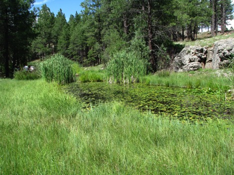
The last stop was a hike to Dow and LO Springs at the south end of Garland Prairie. Part of the trail fallows an old narrow gage railroad bed used to transport Ponderosa Pine to lumber mills in the Williams area from the 1890 to about 1942. LO Spring is unique for the (endemic?) lily pads that cover the ponds and stream channel. During our visit, some of the lilies were in bloom with fist sized buttercup yellow flowers.
The field trip ended back in Williams where most or the party adjourned to the Cruisers Café for drinks, hors d’oeuvres, and continued discussing the field trip and other topics of interest.
The Flagstaff Chapter has a track record of hosting successful and fun field trips for AHS and interested members of the general public. We hope to see you at our next excursion for all of the opportunities it provides to meet, greet, and learn more about the environments of the Southwest.