 Note: Ann Youberg and Joe Cook will be presenting a talk on this research at the upcoming AHS Symposium in Flagstaff.
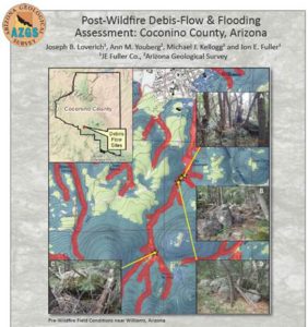
The Arizona Geological Survey released today an open-file report involving a joint project with JE Fuller that identifies areas at risk from flooding and debris flows in the aftermath of a reasonable-scenario wildfire in Coconino County. The report is online and available for download at the AZGS Document Repository.
According to first author Joe Loverich, this work can propel “forest health initiatives forward in these at risk watersheds.” The 63-page report includes six appendices.
After completing a county-wide reconnaissance evaluation, the research team focused on two pilot-study areas: Fort Valley and the City of Williams. The report results integrate field studies; FLO2D pre- and post-wildfire flood modeling; and debris-flow probability, volume; and runout modeling to provide risk maps and identify mitigation options and opportunities. Conversations to implement mitigation options are in progress.
Citation. Loverich, J.B., Youberg, A.M., Kellogg, M.J. and Fuller J.E., 2017, Post-Wildfire Debris-flow and Flooding Assessment: Coconino County, Arizona. Arizona Geological Survey Open-File Report (OFR-17-06), 63 p., 6 appendices.
For additional information, contact Mike Conway or Ann Youberg.