AZGS has revised not only 12 maps for earth fissure study areas but also the statewide fissure geodatabase, Locations of Mapped Earth Fissure Traces in Arizona V06.01.2019.
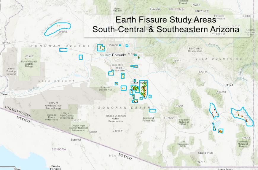
- Apache Junction – Includes detailed mapping of existing fissures north of W. Houston Ave., south of Baseline Ave, and in the southern portion of the study area. Several small unconfirmed fissures near W. Guadalupe Rd. and S. Pinal Dr. were removed from this map based on subsurface investigations of consulting geologists.
- Chandler Heights – Minor additional mapping of small fissures near W. Hunt Highway and N. Thompson Rd.
A small unconfirmed fissure near the foot of the San Tan Mountains was removed from the study area map on the basis of re-examination of source map(s) and historical aerial photos. - Dragoon Rd – Includes mapping of a new fissure (August 2018) crossing W. Dragoon Rd. near AZ 191.
- Harquahala Plain – Chiefly includes fissure extension at the southeast end of the Rogers fissure.
- Heaton – Extension of the Heaton study area to include fissures within the Gila River Indian Reservation that are visible in aerial imagery. These fissures were not field checked.
- Luke – Removed several unconfirmed fissures north of Northern Ave. and south of Glendale Ave. based on review of source map accuracy and subsurface investigations performed by consulting geologists.
- McMullen Valley – Includes traces of a new cluster of earth fissures in the southwest portion of the study area.
- Sacaton Butte – Revised line types, from unconfirmed to confirmed-unsurveyed, for fissures located on tribal lands.
- Santa Rosa Wash – New fissures identified in the west-central portion of the study area. On the basis of aerial photo evidence, the fissures formed between April 2017 and April 2018.
- Tator Hills – New fissure mapping south of the agricultural footprint near the Tator Hills. Previously unconfirmed fissures on nearby agricultural areas are reclassified confirmed-unsurveyed.
- Toltec Buttes – Edits to linework after closely reviewing aerial photographs; several unconfirmed fissures were reclassified as confirmed-unsurveyed.
- White Horse Pass – Edits to linework after closely reviewing aerial photographs; several unconfirmed fissures were reclassified as confirmed-unsurveyed.
For more information, visit the recent blog post, “The ineluctable march of earth fissures in southern Arizona.”
The AZGS maintains two online document repository — its principal repository and a second, archival repository, which is hosted at the University of Arizona Library.